


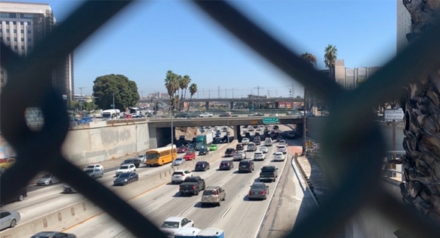
A lifelong resident of East Los Angeles recounted the struggles she faced while growing up in a home approximately 800 feet from the 5 freeway.
“I recall always feeling pain in my lungs,” said Adelita Valentina, who moved away from her family home over a decade ago. “I haven’t felt that lung pain for at least 10 years.”
A UT Community News analysis of state data shows that the rates of air pollutants — specifically, diesel and PM2.5, or fine inhalable particulate matter — were 49% and nearly 8% higher, respectively, in communities on and near the Eastside than those on the western side of the city and county.
At the same time, the poverty rate — 1,604 per 100,000 people — was also 2.4 times higher in those Eastside communities.
The air quality data analyzed is from 2011 to 2013, the most recent data available, and the demographic data is from 2011 to 2015, and it comes from CalEnviroscreen. This tool was developed by the California Environmental Protection Agency and the California Office of Health Hazard Assessment. Their goal was to identify communities most affected by pollution, combine that with socioeconomic and health factors and determine a score to show which communities need the most environmental protection.
Major sources of air pollution in Los Angeles include cars, trucks, heavy machinery and even household items that run on gasoline like barbecues and lawnmowers, according to Stephen LaDochy, an environmental science professor at Cal State LA.
“What happens with most air pollutants is that they affect the respiratory system, the lungs” and can increase the risk of asthma, he said. Air pollution “can cause bronchitis, those kinds of problems where it is difficult to breathe” and can exacerbate other health conditions.
Long-term exposure to high levels of certain toxins has been linked to cancer and substances with metals like lead that can inhibit normal brain development.
The rates of asthma in communities on the Eastside and in and near South L.A. were also 97% and 148% higher, respectively, than communities examined on the western side, according to 2016 data.
Ariana Rodriguez, who has lived in the City Terrace neighborhood on the Eastside her whole life, said she was surprised by the findings but they make sense when you think about all the highways and industrial zones in the area.
“We’re this perfect little pocket where we are bordered…by the 10 freeway below us. And just above us…we are zoned for heavy manufacturing and commercial industrial use,” Rodriguez said.
She added that she feels communities of color have been more affected by the pollution because they have been pushed out of the more lucrative areas of the city over time by rising housing costs.
“This is a racial justice issue. It’s a reproductive justice issue. It’s an economic justice issue. We’re a community with one of the highest populations of Latinos, and we are a predominantly low-income community of working-class people…our community is built in a pollution pocket. And I guarantee you, no pocket of residents would exist like this in Beverly Hills,” she said.
The 2015 documentary, “The East L.A. Interchange,” captures the community’s fight against the freeways when they were being built and some of the impacts since.
Heidi Rous, director of the air quality and noise group at Environmental Science Associates, said cities can create and enforce better zoning policies to address disparities.
For instance, new housing should only be approved far away from freeways and industrial areas. She recommends the city weatherstrip the windows in new affordable housing complexes to help reduce people’s exposure to pollutants while indoors.
She said individual homeowners, renters and landlords could also fix or replace their stove and air conditioning to units that are more environmentally friendly.
Sophia Torres, a Cal State LA student who has lived in Southeast LA near the 5 freeway her entire life, said “there’s definitely more that can be done to reduce pollution…like holding the companies that are around accountable for keeping it cleaner.”
The California Environmental Protection agency has set forth a plan to give disadvantaged communities California Climate Investments (CCI), which are community investments aimed at improving the quality of life for the residents in these areas.
Rodriguez, the City Terrace resident, said local leaders have the chance to make a real difference in the lives of their constituents and to truly effectuate social change.
“It would take such real commitment and resource investment and time to mitigate the heavy pollution that is caused by the freeways,” she said. “While the community has the power and ability to come together and make change and to fight for those mitigating things, I also think it’s the responsibility of the county and the city.”
A tool designed to help identify and address disparities
CalEnviroscreen was created in order to identify the disadvantaged communities that are targets for California’s cap-and-trade program which invests in these communities with the goal of improving public health and reducing the levels of pollution.
When Senate Bill 535 was passed in 2012, it allocated more funds from the cap-and-trade program to disadvantaged communities. The legislation tasked the California Environmental Protection Agency with identifying the communities that would receive the investments, which ultimately led to the creation of CalEnviroScreen.
“Under Senate Bill 535, which is essentially a designation that allows for certain resources to be directed to this to communities that are that are so identified … there was a decision to identify the highest 25% of CalEnviroScreen scores for the purpose of being designated as disadvantaged communities,” said John Faust, chief of OEHHA’s Community and Environmental Epidemiology Research Branch, the branch that developed CalEnviroScreen.
Through years of gathering data, CalEnviroScreen created a comprehensive dataset that accounts for every census tract within California and showcases all of the indicators that they took into account for the identification of the most disadvantaged communities. They then give this information to the California Environmental Protection Agency where they make the determination of how the data provided from the tool is used and what communities receive funding to improve their environment.
The data generally shows that Los Angeles is in the higher percentile range in comparison to the CES scores for the rest of the state, with some areas in Los Angeles going as high as the 95th percentile of overall scores, meaning the pollution levels in combination with the socioeconomic and health factors have identified these areas as worse off than 95% of the state.
Community News reporters are enrolled in JOUR 3910 – University Times. They produce stories about under-covered neighborhoods and small cities on the Eastside and South Los Angeles. Please email feedback, corrections and story tips to [email protected].

Betsy Kalin • Dec 28, 2020 at 10:09 am
Thank you for referring to the documentary “East LA Interchange!” It’s available to watch on Amazon Prime, YouTube, Tubi, Vudu and Google Play.. https://eastlainterchangefilm.com/